Big Data and Machine Learning
-
Object detection in airborne laser scanning (ALS) data using deep learningIn partnership with the Lower Saxony State Office for Preservation of Historic Monuments, we are developing a method for automatically detecting archaeological objects in airborne laser scanning data. The type of objects to be detected are mainly those of interest by archaeologists such as heaps, shafts, charcoal piles, pits, barrows, bomb craters, hollow ways, etc. They could be point, linear, or areal objects. To this end, we are using deep learning techniques; namely, convolutional neural networks (CNNs) to classify height images from the region of interest. A combination of multiple (in most cases 5) CNN classifiers are then used to detect and localize objects of interest in a digital terrain model acquired from the region of interest.Team:Year: 2018Funding: MWK Pro*Niedersachsen
![]()
![]()


Generalization
-
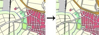
PUSH -- Automatic Cartographic Displacement Based on OptimizationThe software program PUSH allows the automatic displacement of geo-objects of all types, i.e. points, lines and polygons. The object characteristics which influence the displacement behaviour can be parametrized in a very flexible way: either object specific or object-class specific. The results allow for an automatic quality control. The program is able to generalize also large data sets.Team:Year: 2021
![]()
![]()
Laser Scanning
-
Object detection in airborne laser scanning (ALS) data using deep learningIn partnership with the Lower Saxony State Office for Preservation of Historic Monuments, we are developing a method for automatically detecting archaeological objects in airborne laser scanning data. The type of objects to be detected are mainly those of interest by archaeologists such as heaps, shafts, charcoal piles, pits, barrows, bomb craters, hollow ways, etc. They could be point, linear, or areal objects. To this end, we are using deep learning techniques; namely, convolutional neural networks (CNNs) to classify height images from the region of interest. A combination of multiple (in most cases 5) CNN classifiers are then used to detect and localize objects of interest in a digital terrain model acquired from the region of interest.Team:Year: 2018Funding: MWK Pro*Niedersachsen
![]()
![]()