Building Flood Risk Mapping from Mobile Mapping Data
| Led by: | Feng |
| Team: | Qing Xiao |
| Year: | 2021 |
| Is Finished: | yes |
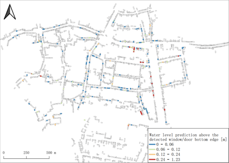
Urban flooding has caused damage to buildings in low-lying areas. Our goal is to detect parts of buildings that are vulnerable to flooding, such as basement windows and doors, based on urban mobile LiDAR data. We mark these risk areas on a map to help people take protective measurements.
First, we extracted building facades based on urban point cloud data from an area in Hildesheim, Germany. We then projected the 3D point cloud of the building facades onto a 2D image and performed object detection on the 2D image. We used a scan line based approach to detect windows and doors. However, this rule-based approach is highly dependent on parameter settings and has low robustness.
Therefore, we consider using the predictions generated by the scan-line based approach as training samples to train a deep learning model. This process requires a small amount of manual annotation of the training samples. To train such a semi-supervised learning model, three datasets were prepared for comparison, namely: all training samples were automatically generated by the scanline based method; the incorrectly detected samples were filtered out as a second dataset; and some of the filtered images were manually relabeled and added to the training dataset to obtain a third dataset.
The model using deep learning improved the F1 score by about 12-14% compared to the scanline based approach. The quality of the generated labels was then manually improved by a workload of approximately 5 hours, which allowed for an increase in the robustness of the detection network and a corresponding increase in the F1-score of approximately 5%. Using the semi-supervised learning model, we achieved a 91% detection result for the F1-score after post-processing. Finally, we used the semi-supervised learning model to detect all images and generate a building flood risk map based on a simulated once in 20 year flood.