Development of an approach for integrating various format data into a 3D voxel-based Urban Digital twin
| Leitung: | Shkedova, Feuerhake, Sester |
| Jahr: | 2023 |
Introduction
The advancements in instruments and methodologies for collecting, transmitting, analyzing, and representing three-dimensional (3D) geodata over the past few decades have opened up extensive possibilities for various applications. 3D geoinformation plays a pivotal role in the operational frameworks of Smart City technology that can be represented within an Urban Digital Twin concept. This involves utilizing diverse data from numerous sensors and designing an adaptive digital model that learns from and evolves alongside the real city.
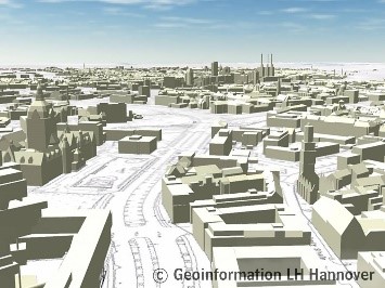
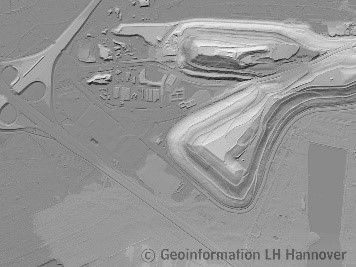
The majority of existing urban digital twins are realized using uniform methods, such as solid 3D models, BIM (Building Information Modeling) and CityGML (City Geography Markup Language) format, additionally involving Digital Terrain Model (DTM). Despite their high accuracy, updating these models frequently to reflect continuous changes in the real world remains challenging. Therefore, an initiative has been proposed to capture the three dimensions of space in a high-resolution digital format and break it down into billions of voxels, systematically addressing and updating them. However, the voxel-based representation is limited to the availability of sensor data. Furthermore, attributive information (e.g., building type, address, land-use category, etc.) is not captured by sensor systems.
To address this, the master's thesis proposes an investigation into how the geometry and attributive information from the CityGML and DTM can contribute to the 3D voxel-based Urban Digital Twin.
Tasks
- Review of relevant literature and existing methods
- Development of an approach for integrating different format data into 3D voxels:
- Investigation of 3D voxel data
- Investigation of existing CityGML data
- Investigation of existing DTM
- Data integration into a 3D voxel-based Urban Digital Twin
- Evaluation of the performed results
- Writing the documentation and the report
Resources
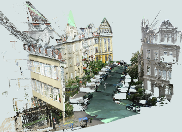
- A 3D voxel grid derived from mobile mapping system measured in urban area of Hannover, CityGML data (LOD2, Hannover), DTM
Requirements
- Knowledge of programming language, such as Python or others.
Contact
M.Sc. Olga Shkedova (olga.shkedova@ikg.uni-hannover.de)
Dr.-Ing Udo Feuerhake (feuerhake@ikg.uni-hannover.de)
Prof. Dr.-Ing. habil. Monika Sester (sester@ikg.uni-hannover.de)
Institut für Kartographie und Geoinformatik, Appelstr. 9a, 30167 Hannover


