Offene Bachelorarbeiten
-
Map-based storytelling of historical sea voyages with a vague spatiotemporal data basisThe thesis topic is related to the DiViAS project (digitization, visualization and analysis of collection items) which brings together scientific methods and practices for digitizing, researching and representing collections from colonial contexts. The project involves developing new approaches for making sense of the information derived from historical sources such as logbooks or travel reports. One of the project goals is to make the movements of ships, people and objects traceable, which can be facilitated by cartographic representations of these movements. In fact, many of these processes can only be understood in a temporal context. Since the information provided in the historical sources is oftentimes vague, inaccurate or incomplete, a visual representation using narrative techniques such as storymapping may facilitate understanding the spatiotemporal sequence of the events that happened throughout the journey.Leitung: Fuest, SesterJahr: 2024
![]()
![]()
-
Detection of Signatures in old Maps using Deep LearningOld maps contain a lot of interesting information of the past reality. Most of maps are, however, only available in analogue form, and thus difficult to query and analyse automatically. The goal of this thesis is to explore modern deep learning methods to automatically detect signatures on old maps. There will be a concentration on certain types of objects, e.g. trees or buildings.Leitung: Thiemann, SesterJahr: 2023
![]()
![]()
-
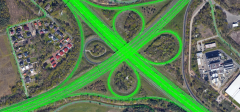
Bestimmung von Mustern in FahrzeugtrajektorienDie Bewegungstrajektorien von Fahrzeugen erlauben Rückschlüsse auf raum-zeitliche Situationen. So können beispielsweise Haltepunkte detektiert werden oder auch Stausituationen, oder auch Anomalien wie temporär nicht zu befahrende Straßensegmente. In der Arbeit sollen in einem großen Trajektoriendatenbestand solche Muster automatisch erkannt werden. Der Datenbestand umfasst sehr viele Trajektorien. Bei Interesse kann ein Schwerpunkt auf die skalierbare Datenanalyse mittels Hadoop und Spark gelegt werden. Je nach Schwerpunkt ist die Arbeit sowohl als Bachelor- als auch als Masterarbeit bearbeitbar.Team:Jahr: 2020
![]()
![]()
-
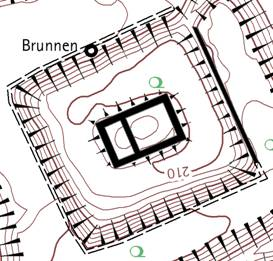
Kartographie: Automatische Platzierung von BöschungsschraffenFür die Darstellung von Wällen und Gräben in archäologischen Plänen werden Schraffen verwendet. Anders als bei neuzeitlichen künstlichen Böschungen sind die historischen Böschungen durch Einwirkung der Erosion sehr unregelmäßig geformt. Standardalgorithmen scheitern aus diesem Grund bei der automatischen Anordnung der Schraffen.Leitung: ThiemannJahr: 2019
![]()
![]()
-
Homogenisierung der GebäudeausrichtungTopographischen Karten 1 : 25.000 werden Gebäude noch grundrissähnlich dargestellt. Detailierte Gebäudegrundrisse aus dem Kataster (ALKIS) müssen dazu generalisert (klassifiziert, selektiert, aggregiert, vereinfacht, betont, verdrängt) werden. Ein Aspekt der Generalisierung ist die homogene Ausrichtung der Gebäude.Leitung: ThiemannJahr: 2019


Offene Masterarbeiten
-
Dynamic Multi-Agent Motion Prediction with Redundancy Reduction and History-Aware InteractionLearning robust representations of the driving environment is a highly challenging task in autonomous driving systems. Current multi-agent motion prediction methods heavily rely on deep neural networks to process rich spatio-temporal traffic information. Transformer-based and graph attention network-based approaches have been widely adopted to model the interactions among traffic participants and between participants and static map elements, followed by trajectory decoders for future behavior prediction. However, as the performance of deep learning models often scales with the amount of training data, the collection and annotation of large-scale datasets can be prohibitively expensive. Consequently, self-supervised learning methods have gained increasing attention, as they can generate supervision signals from unlabeled data.Leitung: Yiming XuJahr: 2025
-
Detecting anomalous sensor data and vehicle trajectories using deep learning methodsAnomaly detection in vehicle trajectories is a critical task in autonomous driving and intelligent transportation systems. Existing methods primarily rely on rule-based approaches or shallow statistical models, which struggle to capture complex spatio-temporal patterns in modern traffic environments. Recent advances in deep learning have demonstrated strong potential in motion prediction, but their application to anomaly detection in vehicle trajectories remains underexplored. This research aims to develop a deep learning-based trajectory anomaly detection framework, focusing on two types of anomalies. The first type arises from sensor errors, leading to abnormal trajectory data that do not reflect the actual vehicle behavior. The second type concerns driving anomalies caused by human errors, such as traffic violations or accidents. The proposed approach will leverage a motion prediction model as a foundation: when the predicted trajectory significantly deviates from the observed trajectory, an anomaly is reported. Furthermore, given the increasing demand for data privacy and the diversity of data sources across different regions and platforms, this research will incorporate a federated learning framework. Federated learning allows collaborative model training across multiple datasets from different organizations or vehicle fleets without sharing raw data. This ensures data privacy while enabling the detection model to generalize to various environments and sensor configurations.Leitung: Yiming XuJahr: 2025
-
Calculation of the itinerary of historical sea voyages with a vague spatiotemporal data basisThe thesis topic is related to the DiViAS project (digitization, visualization and analysis of collection items) which brings together scientific methods and practices for digitizing, researching and representing collections from colonial contexts. The project involves developing new approaches for making sense of the information derived from historical sources such as logbooks or travel reports. One of the project goals is to make the movements of ships, people and objects traceable, which can be facilitated by cartographic representations of these movements. Since the information provided in the historical sources is oftentimes vague, inaccurate or incomplete, the challenge here is to estimate the itinerary of a ship by taking a certain degree of vagueness into account.Leitung: Fuest, SesterJahr: 2024
![]()
![]() © Staatsbibliothek zu Berlin ‐ Kartenabteilung
© Staatsbibliothek zu Berlin ‐ Kartenabteilung
-
Map-based storytelling of historical sea voyages with a vague spatiotemporal data basisThe thesis topic is related to the DiViAS project (digitization, visualization and analysis of collection items) which brings together scientific methods and practices for digitizing, researching and representing collections from colonial contexts. The project involves developing new approaches for making sense of the information derived from historical sources such as logbooks or travel reports. One of the project goals is to make the movements of ships, people and objects traceable, which can be facilitated by cartographic representations of these movements. In fact, many of these processes can only be understood in a temporal context. Since the information provided in the historical sources is oftentimes vague, inaccurate or incomplete, a visual representation using narrative techniques such as storymapping may facilitate understanding the spatiotemporal sequence of the events that happened throughout the journey.Leitung: Fuest, SesterJahr: 2024
![]()
![]()
-
Automatische Annotation historischer KartenSuchmaschinen ermöglichen einen schnellen und gezielten Zugriff auf gespeicherte Inhalte im Internet. Voraussetzung dafür ist jedoch, dass diese Inhalte durch Schlüsselwörter oder Metadaten beschrieben sind. Bei der Suche nach Karten werden typischerweise die Namen oder Kartentypen als Schlüsselwörter verwendet. Will man jedoch auf Karteninhalte zugreifen, zum Beispiel auf Karten mit Laubwäldern, ist es notwendig, dass diese Karteninhalte auch durch Metadaten beschrieben sind. Gleichermaßen sind solche Beschreibungen auch erforderlich, um Blinden oder Menschen mit visuellen Einschränkungen einen Zugang zu ermöglichen Hier setzt die Masterarbeit an: Mit Hilfe von Deep-Learning-Methoden soll eine sogenannte semantische Segmentierung der Karteninhalte in mehrere Landnutzungsklassen vorgenommen werden. Diese Informationen sollen dann in geeigneter Form als Metadaten beschrieben und den Daten hinzugefügt werden.Leitung: Yuan, SesterJahr: 2024
![]()
![]()
-
Dynamic Urban Digital Twin Representation via Spatio-Temporal Voxel MeshingUrban digital twins are virtual models that integrate real-time data to simulate and analyze cities, providing valuable insights for urban planning, traffic management, environmental monitoring, and disaster response. A common approach for creating these 3D models is voxel-based representation, where urban environments are represented by small cubic units (voxels). While offering high resolution, updating such detailed models in real time can be computationally expensive, especially for large urban areas. In highly detailed voxel models, updating each individual voxel—such as in a 10 cm resolution grid—can become inefficient, especially when many areas of the city remain stable over time.Leitung: Shkedova, SesterJahr: 2024
![Dynamic Urban Digital Twin Representation via Spatio-Temporal Voxel Meshing]()
![Dynamic Urban Digital Twin Representation via Spatio-Temporal Voxel Meshing]()
-
Interactive Visualization of Parking Occupancy over Time in a 3D Urban Digital Twin Web ApplicationIntroduction In today's rapidly growing urban environments, efficient parking management has become a crucial challenge. As cities expand, the demand for parking spaces increases, making it essential to monitor parking occupancy in real-time or over time. Integrating this information into modern virtual 3D models of real-world cities (urban digital twins) provides an effective way to visualize parking space availability, helping reduce congestion and optimize urban mobility. However, the challenge lies in effectively visualizing parking occupancy within a 3D urban model. Unlike traditional 2D maps, 3D visualizations offer a more immersive and detailed perspective, but conveying time-dependent data—such as parking space availability at different times—within this context can be complex. Traditional 2D visualizations often use color codes or simple markers to represent occupancy status, but translating this into a 3D environment requires developing an intuitive system that allows users to interact with both the spatial and temporal dimensions of the data. The goal of this thesis is to design an interactive and user-friendly visualization approach that presents parking occupancy information in a way that allows users to explore both current occupancy states and historical data within a 3D urban digital twin.Leitung: Shkedova, SesterJahr: 2024
![Interactive Visualization of Parking Occupancy over Time in a 3D Urban Digital Twin Web Application]()
![Interactive Visualization of Parking Occupancy over Time in a 3D Urban Digital Twin Web Application]()
-
Development of a Mobile Web Application with Augmented and Mixed Reality FeaturesAugmented Reality (AR) and Mixed Reality (MR) are rapidly evolving technologies that provide new opportunities for the visualization and interaction with spatial data. Mobile devices, equipped with advanced sensors and cameras, make AR/MR accessible to a broad audience, enabling innovative applications in the geoinformatics domain. Despite recent advancements, challenges remain in determining the precise pose of the mobile device and accurately localizing virtual objects within the real-world environment. Addressing these challenges is critical for delivering effective AR/MR solutions. The goal of this thesis is to develop a mobile web application featuring AR/MR capabilities using HTML, JavaScript, and other relevant web technologies. The application should leverage device sensors to determine the current pose of the phone (position and orientation) and localize virtual objects in the physical world.Leitung: FeuerhakeJahr: 2024
![]()
![]()
-
Detection of Signatures in old Maps using Deep LearningOld maps contain a lot of interesting information of the past reality. Most of maps are, however, only available in analogue form, and thus difficult to query and analyse automatically. The goal of this thesis is to explore modern deep learning methods to automatically detect signatures on old maps. There will be a concentration on certain types of objects, e.g. trees or buildings.Leitung: Thiemann, SesterJahr: 2023
![]()
![]()
-
Localization of mobile objects in the Absence of GPS/GNSS: A Hybrid 2D-3D ApproachIn today's dynamic landscape of autonomous vehicles and robotics, accurate and real-time localization is imperative. While 3D methods have been employed for vehicle localization, their time-consuming nature poses challenges. This research seeks to a novel hybrid approach, bridging the efficiency of 2D methods with the precision of 3D refinement, to offer a faster and more robust solution for vehicle localization.Leitung: Mortazavi, SesterJahr: 2023
![]()
![]()
-
Mobile Mapping Bike LiDAR EvaluationDas ikg setzt bereits seit einigen Jahren ein Auto basiertes LiDAR Mobile Mapping System zum Erfassen von Punktwolken ein. Diesen bieten vielfältige Analyse- und Visualisierungsmöglichkeiten. Allerdings ist die Nutzung des Messsystems auf mit dem Auto befahrbare Straßen beschränkt und die Prozessierung hängt von proprietärer Software ab. Um die Nutzungsmöglichkeiten zu erweitern wurde daher am ikg ein Lastenfahrrad basiertes Mobile Mapping System konstruiert. Dazu wurde ein Trike mit E-Unterstützung um ein Multisensorsystem erweitert, bestehend aus: LiDAR, RTK-GNSS, IMU und Erweiterungsmöglichkeiten um z.B. eine Thermalkamera. Dank der robusten Positionierung sind auch Messfahrten durch partiell abgeschattete Bereich (auch durch Innenbereiche) möglich. Auf dem Bordrechner werden die eingehenden Sensorstreams mittels ROS aufgezeichnet und bieten so individuelle Möglichkeiten zur weiteren Verarbeitung und Erweiterung des Systems. Ziel einer Abschlussarbeit wäre die Evaluation der resultierenden Punktwolke in Hinblick auf ihre relative Genauigkeit, sowie im Vergleich zum hochgenauen bisherigen System.Leitung: Schimansky, WageJahr: 2023
![]()
![]()
-
Bestimmung von Mustern in FahrzeugtrajektorienDie Bewegungstrajektorien von Fahrzeugen erlauben Rückschlüsse auf raum-zeitliche Situationen. So können beispielsweise Haltepunkte detektiert werden oder auch Stausituationen, oder auch Anomalien wie temporär nicht zu befahrende Straßensegmente. In der Arbeit sollen in einem großen Trajektoriendatenbestand solche Muster automatisch erkannt werden. Der Datenbestand umfasst sehr viele Trajektorien. Bei Interesse kann ein Schwerpunkt auf die skalierbare Datenanalyse mittels Hadoop und Spark gelegt werden. Je nach Schwerpunkt ist die Arbeit sowohl als Bachelor- als auch als Masterarbeit bearbeitbar.Team:Jahr: 2020
![]()
![]()


Kontakt für allgemeine Fragen zu Studien- und Abschlussarbeiten
Dipl.-Ing. Frank Thiemann
Telefon
Fax
Adresse
Appelstraße 9a
30167 Hannover
30167 Hannover
Gebäude
Raum
Sprechzeiten
nach Vereinbarung
Dipl.-Ing. Frank Thiemann


