Offene Bachelorarbeiten
-
Detection of Signatures in old Maps using Deep LearningOld maps contain a lot of interesting information of the past reality. Most of maps are, however, only available in analogue form, and thus difficult to query and analyse automatically. The goal of this thesis is to explore modern deep learning methods to automatically detect signatures on old maps. There will be a concentration on certain types of objects, e.g. trees or buildings.Leitung: Thiemann, SesterJahr: 2023
![]()
![]()
-
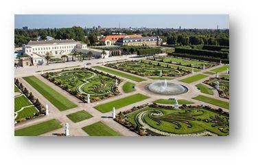
Exploring Herrenhausen GardensDevelopment of an Location Based Interactive Mobile Web Application for Enriching Visitors' Knowledge and ExperienceLeitung: Feuerhake, SesterJahr: 2023
![]()
![]()
-
Unveiling the Wireless JungleWith the increasing amount of wearables, electric cars and wide spread of WiFi home routers, the density and variety of wireless signals is increasing drastically. Different types of connections such as WiFi, Bluetooth, Bluetooth Low Energy and LTE is found in every European city. Even if they are not directly visible, it is possible to capture the emitted signals, e.g. via smartphone. Depending on the topic, there could be various analysis approaches with different goals for working with this type of data. However, the first step is always to collect additional data in order to become familiar with the process of collecting and exploring the data itself.Leitung: Schimansky, GolzeJahr: 2023
![]()
![]()
-
Mobile Mapping Bike LiDAR EvaluationDas ikg setzt bereits seit einigen Jahren ein Auto basiertes LiDAR Mobile Mapping System zum Erfassen von Punktwolken ein. Diesen bieten vielfältige Analyse- und Visualisierungsmöglichkeiten. Allerdings ist die Nutzung des Messsystems auf mit dem Auto befahrbare Straßen beschränkt und die Prozessierung hängt von proprietärer Software ab. Um die Nutzungsmöglichkeiten zu erweitern wurde daher am ikg ein Lastenfahrrad basiertes Mobile Mapping System konstruiert. Dazu wurde ein Trike mit E-Unterstützung um ein Multisensorsystem erweitert, bestehend aus: LiDAR, RTK-GNSS, IMU und Erweiterungsmöglichkeiten um z.B. eine Thermalkamera. Dank der robusten Positionierung sind auch Messfahrten durch partiell abgeschattete Bereich (auch durch Innenbereiche) möglich. Auf dem Bordrechner werden die eingehenden Sensorstreams mittels ROS aufgezeichnet und bieten so individuelle Möglichkeiten zur weiteren Verarbeitung und Erweiterung des Systems. Ziel einer Abschlussarbeit wäre die Evaluation der resultierenden Punktwolke in Hinblick auf ihre relative Genauigkeit, sowie im Vergleich zum hochgenauen bisherigen System.Leitung: Schimansky, WageJahr: 2023
![]()
![]()
-
Bestimmung von Mustern in FahrzeugtrajektorienDie Bewegungstrajektorien von Fahrzeugen erlauben Rückschlüsse auf raum-zeitliche Situationen. So können beispielsweise Haltepunkte detektiert werden oder auch Stausituationen, oder auch Anomalien wie temporär nicht zu befahrende Straßensegmente. In der Arbeit sollen in einem großen Trajektoriendatenbestand solche Muster automatisch erkannt werden. Der Datenbestand umfasst sehr viele Trajektorien. Bei Interesse kann ein Schwerpunkt auf die skalierbare Datenanalyse mittels Hadoop und Spark gelegt werden. Je nach Schwerpunkt ist die Arbeit sowohl als Bachelor- als auch als Masterarbeit bearbeitbar.Team:Jahr: 2020
![]()
![]()
-
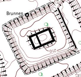
Kartographie: Automatische Platzierung von BöschungsschraffenFür die Darstellung von Wällen und Gräben in archäologischen Plänen werden Schraffen verwendet. Anders als bei neuzeitlichen künstlichen Böschungen sind die historischen Böschungen durch Einwirkung der Erosion sehr unregelmäßig geformt. Standardalgorithmen scheitern aus diesem Grund bei der automatischen Anordnung der Schraffen.Leitung: ThiemannJahr: 2019
![]()
![]()
-
Homogenisierung der GebäudeausrichtungTopographischen Karten 1 : 25.000 werden Gebäude noch grundrissähnlich dargestellt. Detailierte Gebäudegrundrisse aus dem Kataster (ALKIS) müssen dazu generalisert (klassifiziert, selektiert, aggregiert, vereinfacht, betont, verdrängt) werden. Ein Aspekt der Generalisierung ist die homogene Ausrichtung der Gebäude.Leitung: ThiemannJahr: 2019


Offene Masterarbeiten
-
Detection of Signatures in old Maps using Deep LearningOld maps contain a lot of interesting information of the past reality. Most of maps are, however, only available in analogue form, and thus difficult to query and analyse automatically. The goal of this thesis is to explore modern deep learning methods to automatically detect signatures on old maps. There will be a concentration on certain types of objects, e.g. trees or buildings.Leitung: Thiemann, SesterJahr: 2023
![]()
![]()
-
Exploring Herrenhausen GardensDevelopment of an Location Based Interactive Mobile Web Application for Enriching Visitors' Knowledge and ExperienceLeitung: Feuerhake, SesterJahr: 2023
![]()
![]()
-
Unveiling the Wireless JungleWith the increasing amount of wearables, electric cars and wide spread of WiFi home routers, the density and variety of wireless signals is increasing drastically. Different types of connections such as WiFi, Bluetooth, Bluetooth Low Energy and LTE is found in every European city. Even if they are not directly visible, it is possible to capture the emitted signals, e.g. via smartphone. Depending on the topic, there could be various analysis approaches with different goals for working with this type of data. However, the first step is always to collect additional data in order to become familiar with the process of collecting and exploring the data itself.Leitung: Schimansky, GolzeJahr: 2023
![]()
![]()
-
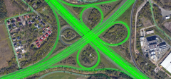
Investigation of the Spatio-Temporal Impact of Traffic AccidentsTraffic accidents play an important role in our lives in terms of safety and security, especially for people. Everyone is affected by traffic accidents either directly (involved) or indirectly (consequences). Consequences such as traffic jams or road (lane) closures not only disrupt delivery and rush hour traffic, but can also lead to additional accidents. In addition, different types of traffic accidents can have different consequences. For example, an impact could be found in a reduction of the average travel speed on the road or on nearby roads in the time after an accident has occurred. The goal of this thesis is to investigate the impact of traffic accidents based on vehicle trajectories. Therefore, accident and trajectory data need to be linked and the spatial and temporal impact needs to be analyzed.Leitung: GolzeJahr: 2023
![]()
![]()
-
Occupancy-free Space Modeling and Navigation Path Planning in a 3D Voxel Grid Environment for Urban Digital Twin ApplicationsThe urban digital twin is an innovative concept within smart city technology, aiming to develop integrated and intelligent systems by harnessing diverse data from a multitude of sensors. Three-dimensional (3D) geodata plays a pivotal role in the representation and operation of urban digital twins. Tasks such as smart space management and navigation have become increasingly essential in urban digital twin applications, and they can be effectively facilitated using a foundation of 3D geospatial data. Therefore, this master thesis focuses on the modeling of unoccupied space and navigation path planning, employing a 3D voxel grid environment representation. The objective of the thesis is to develop a suitable approach for defining vacant space within urban area, which is utilized to enable collision-free 3D navigation. To achieve this, it is proposed to integrate the point cloud data of the Hannover urban area into a 3D voxel grid structure. In this context, grid cells containing point cloud data are treated as obstacles, while unoccupied cells are collectively constitute the occupancy-free space. The identified vacant space serve as a graph for implementing the shortest path algorithm. Ultimately, both the occupancy-free space and an illustrative route through it are visualized to demonstrate the approach viability.Leitung: Shkedova, FeuerhakeTeam:Jahr: 2023
-
Development of an approach for integrating various format data into a 3D voxel-based Urban Digital twinThe advancements in instruments and methodologies for collecting, transmitting, analyzing, and representing three-dimensional (3D) geodata over the past few decades have opened up extensive possibilities for various applications. 3D geoinformation plays a pivotal role in the operational frameworks of Smart City technology that can be represented within an Urban Digital Twin concept. This involves utilizing diverse data from numerous sensors and designing an adaptive digital model that learns from and evolves alongside the real city.Leitung: Shkedova, Feuerhake, SesterJahr: 2023
![]()
![]()
-
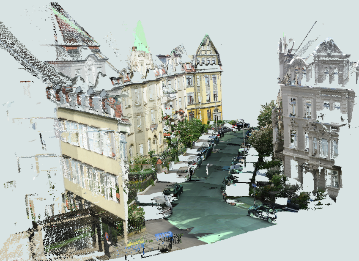
Localization of mobile objects in the Absence of GPS/GNSS: A Hybrid 2D-3D ApproachIn today's dynamic landscape of autonomous vehicles and robotics, accurate and real-time localization is imperative. While 3D methods have been employed for vehicle localization, their time-consuming nature poses challenges. This research seeks to a novel hybrid approach, bridging the efficiency of 2D methods with the precision of 3D refinement, to offer a faster and more robust solution for vehicle localization.Leitung: Mortazavi, SesterJahr: 2023
![]()
![]()
-
Evaluating uncertainty estimation techniques using deep leaning models for classification of point cloudsDeep learning models have proven their ability to perform powerful classification and segmentation considering both 2d and 3D datasets. However, these classifications are often assumed to be accurate, without providing how reliable are these decisions made by the model. There are some possible techniques to convert a stochastic deep learning model into a probabilistic one, to provide a distribution over the weights, instead of finding point estimation for them, leading to an output distribution. Such distribution over output of a model shows not only the true class but also its reliability as the variance of the distribution.Leitung: ShojaeiJahr: 2023
-
Bestimmung von Mustern in FahrzeugtrajektorienDie Bewegungstrajektorien von Fahrzeugen erlauben Rückschlüsse auf raum-zeitliche Situationen. So können beispielsweise Haltepunkte detektiert werden oder auch Stausituationen, oder auch Anomalien wie temporär nicht zu befahrende Straßensegmente. In der Arbeit sollen in einem großen Trajektoriendatenbestand solche Muster automatisch erkannt werden. Der Datenbestand umfasst sehr viele Trajektorien. Bei Interesse kann ein Schwerpunkt auf die skalierbare Datenanalyse mittels Hadoop und Spark gelegt werden. Je nach Schwerpunkt ist die Arbeit sowohl als Bachelor- als auch als Masterarbeit bearbeitbar.Team:Jahr: 2020
![]()
![]()


Kontakt für allgemeine Fragen zu Studien- und Abschlussarbeiten


Dipl.-Ing. Frank Thiemann
Telefon
Fax
Adresse
Appelstraße 9a
30167 Hannover
30167 Hannover
Gebäude
Raum
Sprechzeiten
nach Vereinbarung
Dipl.-Ing. Frank Thiemann


