Development of environmentally-balaced and congestion-avoiding routing algorithms by means of traffic simulation
| Led by: | Sester, Fuest |
| Team: | Christian Hartberger |
| Year: | 2019 |
| Is Finished: | yes |
Due to the constantly growing volume of traffic in urban environments and the resulting problems such as increased air pollution, environmentally oriented approaches to achieve better urban sustainability of transport play an increasingly important role. This thesis deals with the development of environmentally-friendly routing algorithms and their validation in traffic simulations. The routing algorithm used is the A* - algorithm using the developed criteria as weights.
The first approach includes sensor-based particulate matter values in the route planning in order to suggest a route to the user that is as health-friendly as possible, but still comes close to the type of a fastest route. This is a compromise between the "fastest route" usually preferred by the driver and a contribution to environmental compatibility. Another approach describes an algorithm based on a vehicle model, which should reduce energy consumption. The resulting expected effect of fuel savings should reduce the related emissions, especially carbon dioxide, but also achieve cost savings. These routing algorithms are then validated in large traffic simulations for the effects mentioned above. Following the measured traffic densities of the simulations, a further congestion avoidance routing algorithm will be developed, which will use the geographical traffic densities depending on the time of day.
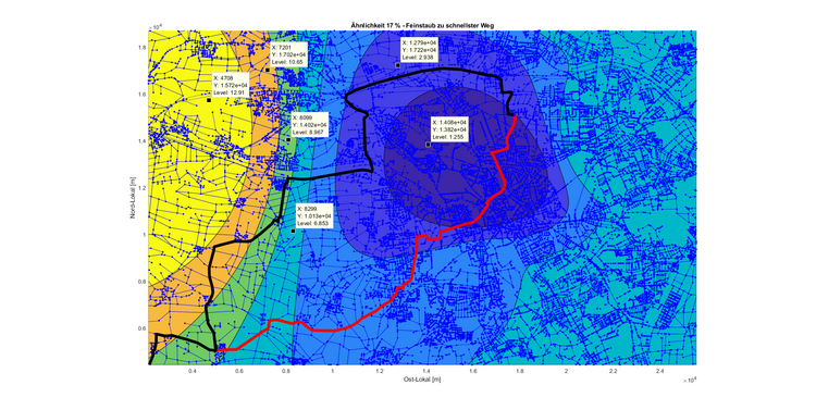
The routing algorithms find their destination in a short time and offer with the configured weights the mentioned desired results and represent compromises between the fastest route and the additional effects of energy minimization and particulate matter pollution. The figure shows two route options, each with start in Barsinghausen and destination in Hannover-Vahrenheide. The routes have a similarity of 17 % (in terms of distance), whereby the black coloured route corresponds to the "fastest route" and the red coloured route was calculated as a result of the "Particulate matter minimisation algorithm". The colored areas correspond to the interpolated particulate matter pollution (orange and yellow are values above 10 and all other colors below 10 μg/m³). If the target is not located in the area polluted by particulate matter, it is always avoided as far as possible.
Altogether, the developed criteria "fastest route", "energy minimization" and "particulate matter" offer a partly unconventional, but logical route according to the required criterion.