Master Theses (finished)
-
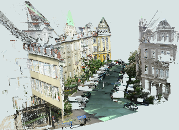
Occupancy-free Space Modeling and Navigation Path Planning in a 3D Voxel Grid Environment for Urban Digital Twin ApplicationsThe urban digital twin is an innovative concept within smart city technology, aiming to develop integrated and intelligent systems by harnessing diverse data from a multitude of sensors. Three-dimensional (3D) geodata plays a pivotal role in the representation and operation of urban digital twins. Tasks such as smart space management and navigation have become increasingly essential in urban digital twin applications, and they can be effectively facilitated using a foundation of 3D geospatial data. Therefore, this master thesis focuses on the modeling of unoccupied space and navigation path planning, employing a 3D voxel grid environment representation. The objective of the thesis is to develop a suitable approach for defining vacant space within urban area, which is utilized to enable collision-free 3D navigation. To achieve this, it is proposed to integrate the point cloud data of the Hannover urban area into a 3D voxel grid structure. In this context, grid cells containing point cloud data are treated as obstacles, while unoccupied cells are collectively constitute the occupancy-free space. The identified vacant space serve as a graph for implementing the shortest path algorithm. Ultimately, both the occupancy-free space and an illustrative route through it are visualized to demonstrate the approach viability.Led by: Shkedova, FeuerhakeTeam:Year: 2023
![]()
![]()
-
Development of an approach for integrating various format data into a 3D voxel-based Urban Digital twinThe advancements in instruments and methodologies for collecting, transmitting, analyzing, and representing three-dimensional (3D) geodata over the past few decades have opened up extensive possibilities for various applications. 3D geoinformation plays a pivotal role in the operational frameworks of Smart City technology that can be represented within an Urban Digital Twin concept. This involves utilizing diverse data from numerous sensors and designing an adaptive digital model that learns from and evolves alongside the real city.Led by: Shkedova, Feuerhake, SesterYear: 2023
![]()
![]()
-
Identification and analysis of movement patterns in trajectoriesIn this work, movement patterns in trajectory datasets are identified with respect to the respective visited locations of a trajectory. For this purpose, further semantic information is assigned to the whereabouts points depending on the position, time of day, and duration of stay; the assignment of semantic information with respect to position is done using OpenStreetMap data. Another focus was on the identification of related trajectory segments, since the given dataset was anonymized as a consequence of data protection; for this purpose, coordinate prediction was performed for all trajectory endpoints in order to identify a suitable continuing starting point of another trajectory using a proximity search and temporal proximity. Recurrent motion pattern detection performed based on the whereabouts points does not produce meaningful patterns detected in multiple trajectories throughout the dataset for the datasets used; however, meaningful recurrent patterns are found for individual trajectories. An increasing level of detail in assigning categories with respect to whereabouts results in fewer recurring patterns, which, on the other hand, allow for greater meaningfulness given the interpretation of an observed person’s movement behavior.Led by: Golze, Feuerhake, Wage, SesterTeam:Year: 2022
-
Development of a modular sensor platform for mobile detection of vehicle encountersRiding a bike in a shared traffic area with motor vehicles causes discomfort for many bicyclists. Avoiding busy roads is only possible with good local knowledge, as no data is available on the frequency of encounters with motor vehicles on most roads. Acquiring a dataset that collects smartphone sensor data on vehicle encounters could become the basis for a smartphone-based vehicle detector. Magnetometer and barometer readings are used as indicators of passing vehicles. In this thesis, a sensor platform is first constructed to collect smartphone and other sensor data while driving. The system is designed to be used with other sensor configurations in the future. A methodology is then presented to create a dataset of vehicle encounters based on data from a camera and a distance sensor on the sensor platform. This data set contains all important sensor data of a commercially available smartphone including the timestamp of vehicle encounters. Finally, a three-class classifier is trained and evaluated based on the data set. It is investigated which approach can provide a generalizable classifier. Approaches based on Random Forests are investigated for the classifier. The structure and parameters of a sliding window function are adjusted for feature generation.Led by: Wage, Feuerhake, Golze, SesterTeam:Year: 2022
![]()
![]()
-
Nutzungsdatengetriebene Analyse des Potentials von MikromobilitätsdienstenDer geteilten Mobilität wird in der öffentlichen Debatte um die Verkehrswende häufig eine entscheidende Rolle zugeordnet. Darunter fallen auch die sogenannten Mikromobilitätsdienste. Das Ziel dieser Masterarbeit ist es, das Potential von Mikromobilitätsdiensten für die Verkehrswende im Hinblick auf die Intentionen der Nutzer, auf zeitliche Variationen, sowie auf Vorteile gegenüber anderen Transportmitteln datenbasiert zu bewerten. Dafür wird eine Fallstudie anhand von Mobilitätsdaten der Bikesharing-Fahrräder und Elektrotretroller zweier Anbieter in Hannover durchgeführt.Led by: Wage, Feuerhake, GolzeTeam:Year: 2022
![]()
![]()


Open Bachelor Theses
-
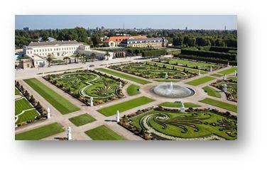
Exploring Herrenhausen GardensDevelopment of an Location Based Interactive Mobile Web Application for Enriching Visitors' Knowledge and ExperienceLed by: Feuerhake, SesterYear: 2023
![]()
![]()
-
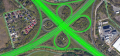
Bestimmung von Mustern in FahrzeugtrajektorienDie Bewegungstrajektorien von Fahrzeugen erlauben Rückschlüsse auf raum-zeitliche Situationen. So können beispielsweise Haltepunkte detektiert werden oder auch Stausituationen, oder auch Anomalien wie temporär nicht zu befahrende Straßensegmente. In der Arbeit sollen in einem großen Trajektoriendatenbestand solche Muster automatisch erkannt werden. Der Datenbestand umfasst sehr viele Trajektorien. Bei Interesse kann ein Schwerpunkt auf die skalierbare Datenanalyse mittels Hadoop und Spark gelegt werden. Je nach Schwerpunkt ist die Arbeit sowohl als Bachelor- als auch als Masterarbeit bearbeitbar.Team:Year: 2020
![]()
![]()

Open Master Theses
-
Dynamic Urban Digital Twin Representation via Spatio-Temporal Voxel MeshingUrban digital twins are virtual models that integrate real-time data to simulate and analyze cities, providing valuable insights for urban planning, traffic management, environmental monitoring, and disaster response. A common approach for creating these 3D models is voxel-based representation, where urban environments are represented by small cubic units (voxels). While offering high resolution, updating such detailed models in real time can be computationally expensive, especially for large urban areas. In highly detailed voxel models, updating each individual voxel—such as in a 10 cm resolution grid—can become inefficient, especially when many areas of the city remain stable over time.Led by: Shkedova, SesterYear: 2024
![Dynamic Urban Digital Twin Representation via Spatio-Temporal Voxel Meshing]()
![Dynamic Urban Digital Twin Representation via Spatio-Temporal Voxel Meshing]()
-
Interactive Visualization of Parking Occupancy over Time in a 3D Urban Digital Twin Web ApplicationIntroduction In today's rapidly growing urban environments, efficient parking management has become a crucial challenge. As cities expand, the demand for parking spaces increases, making it essential to monitor parking occupancy in real-time or over time. Integrating this information into modern virtual 3D models of real-world cities (urban digital twins) provides an effective way to visualize parking space availability, helping reduce congestion and optimize urban mobility. However, the challenge lies in effectively visualizing parking occupancy within a 3D urban model. Unlike traditional 2D maps, 3D visualizations offer a more immersive and detailed perspective, but conveying time-dependent data—such as parking space availability at different times—within this context can be complex. Traditional 2D visualizations often use color codes or simple markers to represent occupancy status, but translating this into a 3D environment requires developing an intuitive system that allows users to interact with both the spatial and temporal dimensions of the data. The goal of this thesis is to design an interactive and user-friendly visualization approach that presents parking occupancy information in a way that allows users to explore both current occupancy states and historical data within a 3D urban digital twin.Led by: Shkedova, SesterYear: 2024
![Interactive Visualization of Parking Occupancy over Time in a 3D Urban Digital Twin Web Application]()
![Interactive Visualization of Parking Occupancy over Time in a 3D Urban Digital Twin Web Application]()
-
Development of a Mobile Web Application with Augmented and Mixed Reality FeaturesAugmented Reality (AR) and Mixed Reality (MR) are rapidly evolving technologies that provide new opportunities for the visualization and interaction with spatial data. Mobile devices, equipped with advanced sensors and cameras, make AR/MR accessible to a broad audience, enabling innovative applications in the geoinformatics domain. Despite recent advancements, challenges remain in determining the precise pose of the mobile device and accurately localizing virtual objects within the real-world environment. Addressing these challenges is critical for delivering effective AR/MR solutions. The goal of this thesis is to develop a mobile web application featuring AR/MR capabilities using HTML, JavaScript, and other relevant web technologies. The application should leverage device sensors to determine the current pose of the phone (position and orientation) and localize virtual objects in the physical world.Led by: FeuerhakeYear: 2024
![]()
![]()
-
Exploring Herrenhausen GardensDevelopment of an Location Based Interactive Mobile Web Application for Enriching Visitors' Knowledge and ExperienceLed by: Feuerhake, SesterYear: 2023
![]()
![]()
-
Bestimmung von Mustern in FahrzeugtrajektorienDie Bewegungstrajektorien von Fahrzeugen erlauben Rückschlüsse auf raum-zeitliche Situationen. So können beispielsweise Haltepunkte detektiert werden oder auch Stausituationen, oder auch Anomalien wie temporär nicht zu befahrende Straßensegmente. In der Arbeit sollen in einem großen Trajektoriendatenbestand solche Muster automatisch erkannt werden. Der Datenbestand umfasst sehr viele Trajektorien. Bei Interesse kann ein Schwerpunkt auf die skalierbare Datenanalyse mittels Hadoop und Spark gelegt werden. Je nach Schwerpunkt ist die Arbeit sowohl als Bachelor- als auch als Masterarbeit bearbeitbar.Team:Year: 2020
![]()
![]()


