Master Theses (finished)
-
Identification and analysis of movement patterns in trajectoriesIn this work, movement patterns in trajectory datasets are identified with respect to the respective visited locations of a trajectory. For this purpose, further semantic information is assigned to the whereabouts points depending on the position, time of day, and duration of stay; the assignment of semantic information with respect to position is done using OpenStreetMap data. Another focus was on the identification of related trajectory segments, since the given dataset was anonymized as a consequence of data protection; for this purpose, coordinate prediction was performed for all trajectory endpoints in order to identify a suitable continuing starting point of another trajectory using a proximity search and temporal proximity. Recurrent motion pattern detection performed based on the whereabouts points does not produce meaningful patterns detected in multiple trajectories throughout the dataset for the datasets used; however, meaningful recurrent patterns are found for individual trajectories. An increasing level of detail in assigning categories with respect to whereabouts results in fewer recurring patterns, which, on the other hand, allow for greater meaningfulness given the interpretation of an observed person’s movement behavior.Led by: Golze, Feuerhake, Wage, SesterTeam:Year: 2022
-
Development of a modular sensor platform for mobile detection of vehicle encountersRiding a bike in a shared traffic area with motor vehicles causes discomfort for many bicyclists. Avoiding busy roads is only possible with good local knowledge, as no data is available on the frequency of encounters with motor vehicles on most roads. Acquiring a dataset that collects smartphone sensor data on vehicle encounters could become the basis for a smartphone-based vehicle detector. Magnetometer and barometer readings are used as indicators of passing vehicles. In this thesis, a sensor platform is first constructed to collect smartphone and other sensor data while driving. The system is designed to be used with other sensor configurations in the future. A methodology is then presented to create a dataset of vehicle encounters based on data from a camera and a distance sensor on the sensor platform. This data set contains all important sensor data of a commercially available smartphone including the timestamp of vehicle encounters. Finally, a three-class classifier is trained and evaluated based on the data set. It is investigated which approach can provide a generalizable classifier. Approaches based on Random Forests are investigated for the classifier. The structure and parameters of a sliding window function are adjusted for feature generation.Led by: Wage, Feuerhake, Golze, SesterTeam:Year: 2022
![]()
![]()
-
Nutzungsdatengetriebene Analyse des Potentials von MikromobilitätsdienstenDer geteilten Mobilität wird in der öffentlichen Debatte um die Verkehrswende häufig eine entscheidende Rolle zugeordnet. Darunter fallen auch die sogenannten Mikromobilitätsdienste. Das Ziel dieser Masterarbeit ist es, das Potential von Mikromobilitätsdiensten für die Verkehrswende im Hinblick auf die Intentionen der Nutzer, auf zeitliche Variationen, sowie auf Vorteile gegenüber anderen Transportmitteln datenbasiert zu bewerten. Dafür wird eine Fallstudie anhand von Mobilitätsdaten der Bikesharing-Fahrräder und Elektrotretroller zweier Anbieter in Hannover durchgeführt.Led by: Wage, Feuerhake, GolzeTeam:Year: 2022
![]()
![]()
-
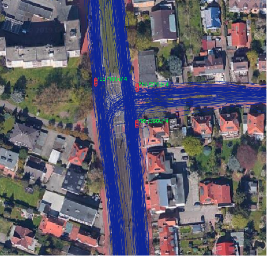
Pattern Recognition of Movement Behavior for Intersection Classification using GPS Trace DataThe aim of this thesis is to classify different regulator types of traffic road intersections based on GPS trace data. To reach this aim a variety of features is calculated to describe the driving behavior at intersections. These are derived from the measured units of the GPS trace data that compose an individual’s movement trajectory.Led by: ZourlidouTeam:Year: 2019
![]()
![]()