Automatic enrichment of route instructions to form a cognitive map

| Team: | Oskar Wage |
| Year: | 2017 |
| Duration: | 2017 |
| Is Finished: | yes |
| Further information | file:2955 |
Commonly used navigation instructions are based on metric turn descriptions (like "turn left onto Nienburger Straße in 100 m"). For the user it is easy to follow the course, but later it is hard to remember how s/he got there.
Natural orientation is based on remarkable objects or locations called landmarks. Multiple of them are combined to the psychological model of a cognitive map, a network of landmarks and connecting actions.
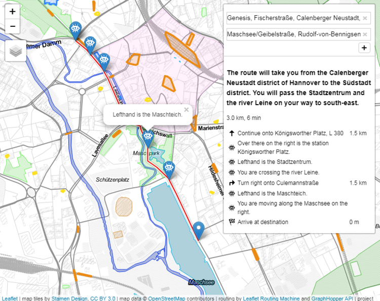
The resulting goal is to enhance the people's own sense of orientation by enriching common routing instruction with hints on landmarks. The automatic description of relevant landmarks along a route is implemented as a interactive web-map.
First, a stock of possible landmarks is extracted from OpenStreetMap data, including a manual ranking of object relevances. In the enrichment process landmarks influence is modeled as a decline of the rank by distance. Afterwards the most powerful landmark is selected for each route segment. The 9-Intersection-Model (for topology) and a adapted Direction-Relation-Matrix are the core methods which are used to analyze the relations between the route and the chosen landmarks.
For a couple of routes the resulting instructions are evaluated in two different ways. One is designed to test people's ability of orientation after using enriched instructions compared to people using classic ones. The other one examines the user's intention of landmark positions resulting from the generated instructions.
