Master Theses (finished)
-
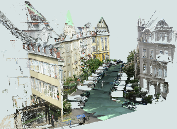
Hololens 2 - Analysis of capabilities and qualityThe Hololens is a device, which captures information of the environment and creates a 3D model of it. At the same time, it is able to place virtual objects into the environment and thus allows AR-applications. The goal of the thesis is to investigate the potential of the Hololens for capturing indoor environments. This includes the acquisition of 3D point clouds and a thorough quality assessment. Subsequently, the point could has to be processed in order to segment important objects or features (e.g. walls, furniture). To this end, the use of Deep Learning models has to be considered.Led by: Kamalasanan, SesterYear: 2023
![]()
![]()
-
Future trajectory and Motion guidance with Augmented realityControlling pedestrian motion pattern using augmented reality would require explainable visualizations to convince the user to change directions and speed of motion. Such AR visualizations should avoid cognitive overload and should provide motion guidance that are accurate representations of expected user actions to avoid conflicts / collisions. The focus of this master thesis would be to design and evaluate 3D motion guidance augmentations using AR emphasizing how such visualizations can avoid collisions between pedestrian / smartphone zombie. The student is expected to design and validate motion guidance visualizations in augmented realityLed by: Kamalasanan, SesterYear: 2023
![]()
![]()
-
Development of an approach for integrating various format data into a 3D voxel-based Urban Digital twinThe advancements in instruments and methodologies for collecting, transmitting, analyzing, and representing three-dimensional (3D) geodata over the past few decades have opened up extensive possibilities for various applications. 3D geoinformation plays a pivotal role in the operational frameworks of Smart City technology that can be represented within an Urban Digital Twin concept. This involves utilizing diverse data from numerous sensors and designing an adaptive digital model that learns from and evolves alongside the real city.Led by: Shkedova, Feuerhake, SesterYear: 2023
![]()
![]()
-
Identification and analysis of movement patterns in trajectoriesIn this work, movement patterns in trajectory datasets are identified with respect to the respective visited locations of a trajectory. For this purpose, further semantic information is assigned to the whereabouts points depending on the position, time of day, and duration of stay; the assignment of semantic information with respect to position is done using OpenStreetMap data. Another focus was on the identification of related trajectory segments, since the given dataset was anonymized as a consequence of data protection; for this purpose, coordinate prediction was performed for all trajectory endpoints in order to identify a suitable continuing starting point of another trajectory using a proximity search and temporal proximity. Recurrent motion pattern detection performed based on the whereabouts points does not produce meaningful patterns detected in multiple trajectories throughout the dataset for the datasets used; however, meaningful recurrent patterns are found for individual trajectories. An increasing level of detail in assigning categories with respect to whereabouts results in fewer recurring patterns, which, on the other hand, allow for greater meaningfulness given the interpretation of an observed person’s movement behavior.Led by: Golze, Feuerhake, Wage, SesterTeam:Year: 2022
-
Development of a modular sensor platform for mobile detection of vehicle encountersRiding a bike in a shared traffic area with motor vehicles causes discomfort for many bicyclists. Avoiding busy roads is only possible with good local knowledge, as no data is available on the frequency of encounters with motor vehicles on most roads. Acquiring a dataset that collects smartphone sensor data on vehicle encounters could become the basis for a smartphone-based vehicle detector. Magnetometer and barometer readings are used as indicators of passing vehicles. In this thesis, a sensor platform is first constructed to collect smartphone and other sensor data while driving. The system is designed to be used with other sensor configurations in the future. A methodology is then presented to create a dataset of vehicle encounters based on data from a camera and a distance sensor on the sensor platform. This data set contains all important sensor data of a commercially available smartphone including the timestamp of vehicle encounters. Finally, a three-class classifier is trained and evaluated based on the data set. It is investigated which approach can provide a generalizable classifier. Approaches based on Random Forests are investigated for the classifier. The structure and parameters of a sliding window function are adjusted for feature generation.Led by: Wage, Feuerhake, Golze, SesterTeam:Year: 2022
![]()
![]()
-
Hololens 2 – Evaluating 3D Mapping and Technical CapabilitiesIn this study, the technical and 3D mapping capabilities of Hololens 2 was evaluated. The Microsoft Hololens 2 is a head-worn mobile mixed reality device that is capable of mapping its direct environment in real time. It is equipped with different sensors including four visible light tracking cameras and a depth sensor. The 3D map created using these sensor streams can be accessed by research mode. This makes Hololens 2 a powerful tool for mapping an indoor space. In this work, we evaluate the capabilities of Hololens 2 with respect to the task of the 3D indoor mapping, semantic segmentation and 3D modelling as the quality of scanned data highly influences the accuracy of reconstruction and segmentation.Led by: Vinu Kamalasanan, Monika SesterTeam:Year: 2022
![]()
![]()
-
Trajectory anomaly detection using spectral clustering and RNN-based auto-encoderAnomaly detection is important, because anomalous behavior may indicate critical events or objects within diverse research areas and application domains. One of such domains is transport, especially integrated urban mobility. Trajectories of moving objects are good representations of their behaviors in surveillance data and useful in detecting anomalous behavior. On one hand, trajectories can provide more agent-based, long-term information comparing with simple physical features. On the other hand, comparing with raw video data, which is usually represented as a sequence of images, trajectory data requires less storage space and computational resources. Moreover, it has a wide variety of sources, such as GPS instruments and laser-scanners.Led by: Sester, KoetsierTeam:Year: 2020
![]()
![]()
-
Development of environmentally-balaced and congestion-avoiding routing algorithms by means of traffic simulationDue to the constantly growing volume of traffic in urban environments and the resulting problems such as increased air pollution, environmentally oriented approaches to achieve better urban sustainability of transport play an increasingly important role. This thesis deals with the development of environmentally-friendly routing algorithms and their validation in traffic simulations. The routing algorithm used is the A* - algorithm using the developed criteria as weights.Led by: Sester, FuestTeam:Year: 2019
![]()
![]()


Open Bachelor Theses
-
Map-based storytelling of historical sea voyages with a vague spatiotemporal data basisThe thesis topic is related to the DiViAS project (digitization, visualization and analysis of collection items) which brings together scientific methods and practices for digitizing, researching and representing collections from colonial contexts. The project involves developing new approaches for making sense of the information derived from historical sources such as logbooks or travel reports. One of the project goals is to make the movements of ships, people and objects traceable, which can be facilitated by cartographic representations of these movements. In fact, many of these processes can only be understood in a temporal context. Since the information provided in the historical sources is oftentimes vague, inaccurate or incomplete, a visual representation using narrative techniques such as storymapping may facilitate understanding the spatiotemporal sequence of the events that happened throughout the journey.Led by: Fuest, SesterYear: 2024
![]()
![]()
-
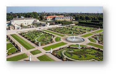
Exploring Herrenhausen GardensDevelopment of an Location Based Interactive Mobile Web Application for Enriching Visitors' Knowledge and ExperienceLed by: Feuerhake, SesterYear: 2023
![]()
![]()
-
Detection of Signatures in old Maps using Deep LearningOld maps contain a lot of interesting information of the past reality. Most of maps are, however, only available in analogue form, and thus difficult to query and analyse automatically. The goal of this thesis is to explore modern deep learning methods to automatically detect signatures on old maps. There will be a concentration on certain types of objects, e.g. trees or buildings.Led by: Thiemann, SesterYear: 2023
![]()
![]()
-
Bestimmung von Mustern in FahrzeugtrajektorienDie Bewegungstrajektorien von Fahrzeugen erlauben Rückschlüsse auf raum-zeitliche Situationen. So können beispielsweise Haltepunkte detektiert werden oder auch Stausituationen, oder auch Anomalien wie temporär nicht zu befahrende Straßensegmente. In der Arbeit sollen in einem großen Trajektoriendatenbestand solche Muster automatisch erkannt werden. Der Datenbestand umfasst sehr viele Trajektorien. Bei Interesse kann ein Schwerpunkt auf die skalierbare Datenanalyse mittels Hadoop und Spark gelegt werden. Je nach Schwerpunkt ist die Arbeit sowohl als Bachelor- als auch als Masterarbeit bearbeitbar.Team:Year: 2020
![]()
![]()


Open Master Theses
-
Calculation of the itinerary of historical sea voyages with a vague spatiotemporal data basisThe thesis topic is related to the DiViAS project (digitization, visualization and analysis of collection items) which brings together scientific methods and practices for digitizing, researching and representing collections from colonial contexts. The project involves developing new approaches for making sense of the information derived from historical sources such as logbooks or travel reports. One of the project goals is to make the movements of ships, people and objects traceable, which can be facilitated by cartographic representations of these movements. Since the information provided in the historical sources is oftentimes vague, inaccurate or incomplete, the challenge here is to estimate the itinerary of a ship by taking a certain degree of vagueness into account.Led by: Fuest, SesterYear: 2024
![]()
![]() © Staatsbibliothek zu Berlin ‐ Kartenabteilung
© Staatsbibliothek zu Berlin ‐ Kartenabteilung
-
Map-based storytelling of historical sea voyages with a vague spatiotemporal data basisThe thesis topic is related to the DiViAS project (digitization, visualization and analysis of collection items) which brings together scientific methods and practices for digitizing, researching and representing collections from colonial contexts. The project involves developing new approaches for making sense of the information derived from historical sources such as logbooks or travel reports. One of the project goals is to make the movements of ships, people and objects traceable, which can be facilitated by cartographic representations of these movements. In fact, many of these processes can only be understood in a temporal context. Since the information provided in the historical sources is oftentimes vague, inaccurate or incomplete, a visual representation using narrative techniques such as storymapping may facilitate understanding the spatiotemporal sequence of the events that happened throughout the journey.Led by: Fuest, SesterYear: 2024
![]()
![]()
-
Automatic annotation of historical map contentSearch enginges enable quick and targeted access to stored content on the Internet. However, the prerequisite for this is that this content is described using keywords or metadata. When searching for maps, the names or map types are typically used as keywords. However, if you want to access map content, for example maps containing deciduous forests, it is necessary that this map content is also described using metadata. Similarly, such descriptions are also necessary to provide access for blind people or people with visual impairments This is where the master thesis comes in: deep learning methods are to be used to perform a so-called semantic segmentation of the map content into several land use classes. This information is then to be described in a suitable form as metadata and added to the data.Led by: Yuan, SesterYear: 2024
![]()
![]()
-
Dynamic Urban Digital Twin Representation via Spatio-Temporal Voxel MeshingUrban digital twins are virtual models that integrate real-time data to simulate and analyze cities, providing valuable insights for urban planning, traffic management, environmental monitoring, and disaster response. A common approach for creating these 3D models is voxel-based representation, where urban environments are represented by small cubic units (voxels). While offering high resolution, updating such detailed models in real time can be computationally expensive, especially for large urban areas. In highly detailed voxel models, updating each individual voxel—such as in a 10 cm resolution grid—can become inefficient, especially when many areas of the city remain stable over time.Led by: Shkedova, SesterYear: 2024
![Dynamic Urban Digital Twin Representation via Spatio-Temporal Voxel Meshing]()
![Dynamic Urban Digital Twin Representation via Spatio-Temporal Voxel Meshing]()
-
Interactive Visualization of Parking Occupancy over Time in a 3D Urban Digital Twin Web ApplicationIntroduction In today's rapidly growing urban environments, efficient parking management has become a crucial challenge. As cities expand, the demand for parking spaces increases, making it essential to monitor parking occupancy in real-time or over time. Integrating this information into modern virtual 3D models of real-world cities (urban digital twins) provides an effective way to visualize parking space availability, helping reduce congestion and optimize urban mobility. However, the challenge lies in effectively visualizing parking occupancy within a 3D urban model. Unlike traditional 2D maps, 3D visualizations offer a more immersive and detailed perspective, but conveying time-dependent data—such as parking space availability at different times—within this context can be complex. Traditional 2D visualizations often use color codes or simple markers to represent occupancy status, but translating this into a 3D environment requires developing an intuitive system that allows users to interact with both the spatial and temporal dimensions of the data. The goal of this thesis is to design an interactive and user-friendly visualization approach that presents parking occupancy information in a way that allows users to explore both current occupancy states and historical data within a 3D urban digital twin.Led by: Shkedova, SesterYear: 2024
![Interactive Visualization of Parking Occupancy over Time in a 3D Urban Digital Twin Web Application]()
![Interactive Visualization of Parking Occupancy over Time in a 3D Urban Digital Twin Web Application]()
-
Exploring Herrenhausen GardensDevelopment of an Location Based Interactive Mobile Web Application for Enriching Visitors' Knowledge and ExperienceLed by: Feuerhake, SesterYear: 2023
![]()
![]()
-
Detection of Signatures in old Maps using Deep LearningOld maps contain a lot of interesting information of the past reality. Most of maps are, however, only available in analogue form, and thus difficult to query and analyse automatically. The goal of this thesis is to explore modern deep learning methods to automatically detect signatures on old maps. There will be a concentration on certain types of objects, e.g. trees or buildings.Led by: Thiemann, SesterYear: 2023
![]()
![]()
-
Localization of mobile objects in the Absence of GPS/GNSS: A Hybrid 2D-3D ApproachIn today's dynamic landscape of autonomous vehicles and robotics, accurate and real-time localization is imperative. While 3D methods have been employed for vehicle localization, their time-consuming nature poses challenges. This research seeks to a novel hybrid approach, bridging the efficiency of 2D methods with the precision of 3D refinement, to offer a faster and more robust solution for vehicle localization.Led by: Mortazavi, SesterYear: 2023
![]()
![]()
-
Bestimmung von Mustern in FahrzeugtrajektorienDie Bewegungstrajektorien von Fahrzeugen erlauben Rückschlüsse auf raum-zeitliche Situationen. So können beispielsweise Haltepunkte detektiert werden oder auch Stausituationen, oder auch Anomalien wie temporär nicht zu befahrende Straßensegmente. In der Arbeit sollen in einem großen Trajektoriendatenbestand solche Muster automatisch erkannt werden. Der Datenbestand umfasst sehr viele Trajektorien. Bei Interesse kann ein Schwerpunkt auf die skalierbare Datenanalyse mittels Hadoop und Spark gelegt werden. Je nach Schwerpunkt ist die Arbeit sowohl als Bachelor- als auch als Masterarbeit bearbeitbar.Team:Year: 2020
![]()
![]()


